Polar View provides a growing community of global users with vital information related to resource development, safety of operations, environmental protection and sustainable economic growth in geographic areas affected by ice and snow.
Oil & GasOrganizations operating in the Oil and Gas sector, including offshore exploration and development companies, engineering consulting firms and oil spill response organizations, need sea ice and iceberg information to support design, operations planning and implementation and emergency response activities. |
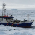
ShippingShipping in the Polar Regions covers many types of vessels, including the full range of merchant and cargo shipping. Shipping vessels require all kinds of sea ice (e.g., ice forecasts, type, concentration, thickness, pressure, drift) and iceberg information for route planning and tactical navigation. |
FishingFishing fleets need sea ice information (e.g., ice forecasts, extent, type, concentration, thickness, pressure, drift) to navigate along the ice edge and into leads. It would also be useful to identify smaller dangerous ice floes of blue ice and to get a rich picture of the ice situation to follow the development of the ice. |
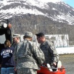
Emergency ManagementEmergency management organizations need snow and ice information to help prevent and respond to emergencies such as floods and avalanches. Search and rescue (SAR) operations need an up to date picture of sea ice and other met-ocean information as part of their common operating picture to inform rescue and recovery operations. |
TourismCruise and other tourism-related operators in the Polar Regions need all kinds of sea ice (e.g., ice forecasts, type, concentration, thickness, pressure, drift) and iceberg information for route planning and tactical navigation. |
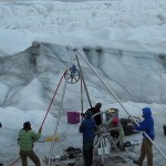
Science & ResearchOrganizations conducting science and research in Polar Regions require sea ice (e.g., ice forecasts, type, concentration, thickness, pressure, drift) and iceberg information to support route planning and tactical navigation. |